History :
- 1519 Alonso de Pi�eda sailed his ships into and spent
40
days in
the Laguna Madre. Reported seeing about forty Indian pueblos below what
is now Brownsville.
- 1520 Eight separate attempts were made to populate
the Rio
de Las
Palmas
area until 1684
- 1520 Camargo brought brick, lime and masons for the
purpose
of
establishing
a settlement on the north bank of the river
- 1523 Francisco Garay arrived in harbor St. James Day
(July
25th) and
named
the harbor Brazos de Santiago, a name which it still holds. He also
established
what would be the first organized government (local) in the U.S.
- 1524-1527? After Garay's death Hernan Cortes
organized
three separate
attempts
to colonize the area of Point Isabel
- 1528 Sancho de Ca�iedo made another failed attempt to
colonize
this
area
- 1553 Wreck of the great Spanish fleet, which cast
about 300
survivors
on
the shore of South Padre Island. All were killed by native Karankawa
Indians,
only two survived to tell the story.
- 1682 Spanish pirate Pe�alosa collaborated with French
to
propose
a settlement at the mouth of the Rio Grande. They departed New Orleans
but reached no further than Galveston in 1684
- 1765 Official confirmation of Land Grant of "La Isla
de la
Laguna" and
las tierras de Azataranas on November 24.
- 1795 Jose Nicolas Balli, inherits "La Isla de
Santiago"
along with the
ranch of "Atazaranas" from his father, will dated August 9. It appears
"Atazaranas" was located across the lagoon, either on the mainland or
on
Brazos Island.
- 1820 Brazos Santiago was known as a Mexican port of
entry
as early as
1820
according to Matamoros customs archives.
- 1823 Fishing Village of El Fronton de Santa Isabel
established.
- 1823 When Matamoros was established, and there was
still no
steamship
traffic,
goods were shipped through Brazos de Santiago to Matamoros over land or
up the Boca Chica beach and upriver.
- 1828 On June 6, a survey of Padre Island was
completed by
Domingo de la
Fuente by order of governor of Tamaulipas, Vital Fernandez
- 1829 Rafael Garcia and Family known to have inhabited
the
area since
1826,
a resident of Matamoros, applies for over seven leagues of land known
as
the Santa Isabel headland. Applied 1827, surveyed and granted 1828
concession
on Mar. 2, 1829
- 1846 General Taylor's forces arrive Point Isabel on
March
27, the
settlement
is already known as El Fronton and is populated by Mexicans.
- 1846 Fort Polk established and served as base of
supplies
for Taylor
1846-1848
- 1846 "The American Flag" an army newspaper reports on
July
21, the
appointment
of postmaster at Point Isabel. Believed to be the first post office
south
of Corpus Christi
- 1847 Simon Mussina established the town of Point
Isabel,
when he
purchased
5/6 of 3 leagues of land including El Fronton de Santa Isabel
- 1848 Ferry opened between Brazos Santiago and Point
Isabel
on Feb
21
- 1850 Town is surveyed as municipality, and platted as
the
"city of
Point
Isabel" Feb 25. The platted city lay westward from the headland along
the
shore of Laguna Madre, and included the area where the Yacht Club and
Yacht
basic are now located.
- 1851 Simon Mussina gives up contract to town and the
lands
revert to
daughter
of original grantee Rafael Garcia.
- 1852 Old lighthouse built on site of Fort Polk. Land
east
of Fort Polk
was not included in the original town site.
- 1852 Point Isabel became less important with the
advent of
the Kenedy
and
Company line of steamships. Brazos remained a principle port, but all
freight
bound for Matamoros traveled by steamship instead of oxcart.
- 1870 Rio Grande railroad built linking Point Isabel
and
Brownsville
- 1870-1904 The "Golden Age" when Point Isabel boomed
and
attracted
millions
in commerce from all over the world.
- 1904 Gulf Coast lines completed, spelled doom ahead
for the
area when
it
upset much of the traditional shipping trade.
- 1908 Charles Champion and James Wells became owners
of the
Point Isabel
town site
- 1908-1927 Point Isabel patronized mainly by
recreation
seekers. The
only
industry was seafood.
- 1927 Town site sold to Capt. C. R.. Tyrell and
associates
on August 30.
1930 Name officially changed from Point Isabel to Port Isabel on August
1
|
Geographical
location:
Land approach -
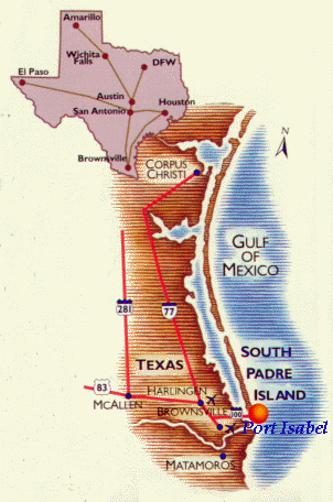
Sea approach:
The Port of Port Isabel is one of
a
select few
classified Texas deep water ports and is positioned at the southernmost
tip of Texas, 29 miles north of the mouthof the Rio Grand River, within
Cameron County, to serve Mexico, Central and South America.
Through the Texas Intercoastal
Waterway,
the Port
can serve points as close as Corpus Christi and as far as
St. Louis and Chicago.
The Port has a mean elevation of
15 feet
above
sea level and is located :
Latitude
:
26 - 05' North
Longitude : 97 - 10' West
which places it in a semi-arid,
subtropical zone
with an annual normal mean temperature of 73.6 F. degrees.
Average rainfall registers
27.62".
Prevailing winds are south /
southeast.
With a controlling depth of 36
feet, the
Port's1000
X 1500 foot Turning Basin allows maneuverability for vessels of up to
700
feet in length.
The Port is situated just 25
minuets
from the
South Padre Jetties and sea lanes, with no overhead obstructions.
Waters interface with the Port
include
Brownsville
Ship Channel, the Intercoastal Waterway, Gulf of Mexico and Port Isabel
Channel.
Port Isabel has several deep water
channels
providing
recreational vessel with up to 8' access to private docking .
For recreational Sailors we want
to
mention that
you have to use the Port Channels to avoid the old power line with
max.OVHD
clearance of 60 feet to get from the ICW to the South Padre Jetties-
and
if you are already in Port Isabel you can make use of the municipal
dock
in the fingers to stay a week for free and fill up on provision before
you cruise into the Golf.
Supermarket are in walking distance
and
Taxi
fare is $ 5,- flat for within Port Isabel city limits. Make use of this
wonderful opportunity to see Port Isabel, shop Port Isabel and lodge in
Port Isabel .
|